Lighthouse landmark · Lagos, Algarve
Farol da Ponta da Piedade
The lighthouse marks the coast from which mariners approach Lagos; its compact utilitarian form contrasts with the irregular erosion of the cliffs.
View exact location on Google Maps ↗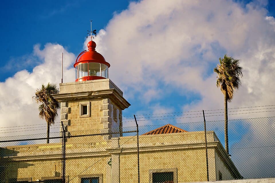
About & stewardship
About Farol da Ponta da Piedade
Farol da Ponta da Piedade belongs to Portugal’s national maritime signalling network, with technical responsibility held by the Direção de Faróis, part of the Direção-Geral da Autoridade Marítima. First lit in 1913, the lighthouse reflects Lagos’s long relationship with Atlantic navigation. The surrounding public coastal paths form part of the wider Ponta da Piedade area, where Lagos Municipality has led improvements to pedestrian access and viewpoints. The lighthouse is an operational navigation facility, so access to its interior is separate from visiting the public headland.
Public authority source: Direção de Faróis — lighthouse history and administration ↗At a glance
Type
Lighthouse landmark
Area
Lagos, Algarve, Portugal
Suggested stop
15–30 minutes plus walking time
Access
Follow current local signs
Explore the setting
The headland lighthouse and its maritime setting at the end of Estrada da Ponta da Piedade. The lighthouse marks the coast from which mariners approach Lagos; its compact utilitarian form contrasts with the irregular erosion of the cliffs. A short pause here works well as part of a wider Ponta da Piedade visit, where the landscape changes noticeably with the direction of the light and sea conditions.
History, geology and character
The Lagos headland has long been connected with Atlantic seafaring and coastal navigation. Its modern visitor infrastructure sits in a landscape shaped by marine erosion, wind and changing shoreline access. Farol da Ponta da Piedade is part of this meeting between human use of the headland and the natural cliffs; observe the materials, practical layout and relationship to nearby paths and viewpoints.
Details to observe
Take time to notice the cliff strata, the way the waves meet the base of the rocks, and the contrast between exposed stone and sparse coastal vegetation. The lighthouse marks the coast from which mariners approach Lagos; its compact utilitarian form contrasts with the irregular erosion of the cliffs. On clear days, small boats offshore offer a sense of scale; in haze or high swell, the same perspective can look very different.
Arrival and transport
Approach by road or on foot from Lagos, then explore only the publicly accessible paths around the lighthouse and boardwalk. From central Lagos, visitors can approach the wider Ponta da Piedade area by road transport or on foot. Parking capacity and permitted driving access can change, especially in busy periods. For the final segment, follow the individual map pin and posted pedestrian signs instead of assuming a straight-line route across the cliffs.
Suggested walking itinerary
1. Begin at a permitted road or pedestrian access point and orient yourself using the dedicated map. 2. Follow established boardwalks and signed paths towards Farol da Ponta da Piedade. 3. Pause to observe the viewpoint and take photographs from safe ground. 4. Continue towards another marked lookout if conditions allow, or return by the same safe route. The lighthouse itself is an operational site; entry to the interior or enclosed grounds cannot be assumed.
Photography positions
Frame the tower from the approach with the coastal horizon and low vegetation to show its relationship to the cape. A wide lens helps communicate the headland's scale, while a moderate zoom isolates details in the rock. Take a second photograph that includes the surrounding path or coastline to provide context; never cross a railing to remove it from the frame.
Practical visiting advice
Bring drinking water, sun protection, shoes with grip and a light layer for Atlantic winds. There is limited shade along much of the exposed coast. The lighthouse itself is an operational site; entry to the interior or enclosed grounds cannot be assumed. Check local notices for any work, closures or weather restrictions, and do not approach the base of cliffs in rough surf.
Frequently asked questions
Where exactly is Farol da Ponta da Piedade?
Use the dedicated map link on this page. The named location sits in the Ponta da Piedade/Lagos coastal area, Algarve, Portugal; the pin is not replaced by the generic lighthouse map.
What makes Farol da Ponta da Piedade worth visiting?
The lighthouse marks the coast from which mariners approach Lagos; its compact utilitarian form contrasts with the irregular erosion of the cliffs.
How should I reach the viewpoint?
Approach by road or on foot from Lagos, then explore only the publicly accessible paths around the lighthouse and boardwalk.
When is the best time for photographs?
Frame the tower from the approach with the coastal horizon and low vegetation to show its relationship to the cape. Softer light near the beginning or end of the day usually helps, although the sun angle changes with the seasons.
Are there entry fees or fixed hours?
Outdoor paths and viewpoints do not necessarily operate like staffed attractions. Check on-site access signs and any seasonal restrictions. Tours, parking or managed facilities may have separate charges.
Is it suitable for children or visitors with limited mobility?
Conditions vary by path and platform. Check slope, stairs, barriers and surface quality locally before setting off. The lighthouse itself is an operational site; entry to the interior or enclosed grounds cannot be assumed.
Location and navigation
The headland lighthouse and its maritime setting at the end of Estrada da Ponta da Piedade. Open the dedicated place listing to check the best current approach; this is not a shared generic map link.
Google Maps: Farol da Ponta da Piedade ↗